

We woke up on Sunday (Nov 22) at The Wharf Marina ready to start the next cruising adventure. After breakfast at the Southern Grind Coffee House, we went back to the boat and started getting ready to go. This involves stowing everything that can move. It also involves setting up navigation plans, plotting routes, checking weather, verifying bridge heights, etc.
A big difference between navigating on land and navigating on water is the three dimensional nature of navigation on water - the depth of the water is critical. While depth is rarely an issue while cruising around your local lake, the Intracoastal Waterway (ICW) is completely different.
When we first started boating on the ICW, we didn't pay much attention to depth. On Jet Skis, you can get away with scooting through two feet of water. You see, while the waterway may appear to be 100 yards wide, only a very narrow part may be more than a few feet deep, especially at low tide. There is a "channel" that is made for navigation.The rest may be 10 ft deep or 6 inches. As we got more experience, we learned that there is a meaning to every marker you see on the water.
Narrow channels on the ICW

Pump out at the marina
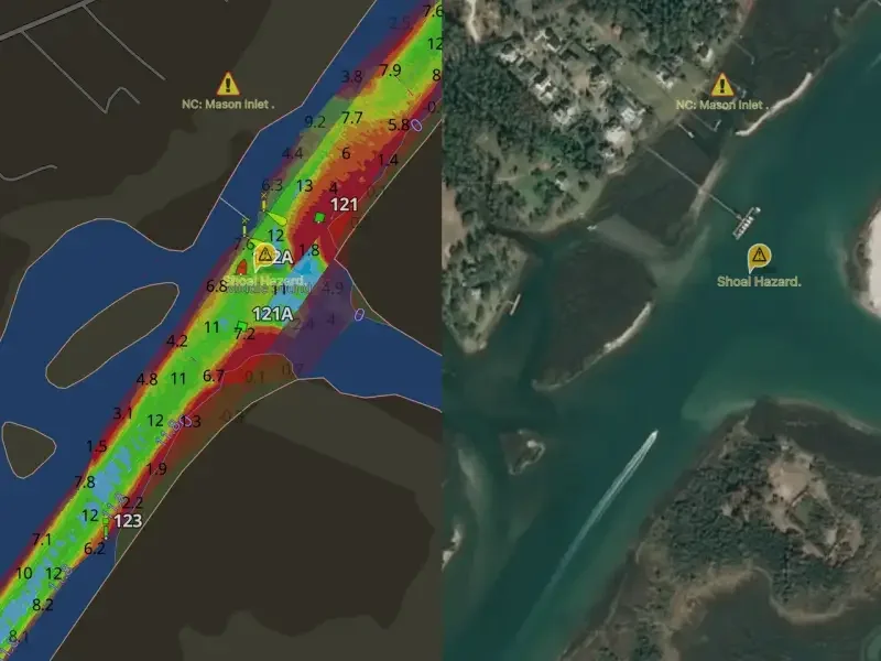
On land, you generally have paved lanes that indicate where you should be. On the water, the lanes are invisible, but they are there. This is a side-by-side picture of the same location with the depths on the left and the satellite image on the right. What appears to be plenty of water on the surface is actually a very narrow channel (the green) surrounded by a lot of shallow spots (red). The good news is that six months from now, the tides, storms, and other events will make this area completely different. The ICW is an amazing resource. It's like an interstate highway of navigable water, allowing you to travel hundreds of miles of coastline in relatively protected waters. But, its ever-changing nature requires constant vigilance.
Back to our trip: We were going to travel east, back past Pensacola to Sandestin Marina. This would be a trip of more than 80 miles, with our first bay crossings and the navigational challenges that come with new territory.
Before we left the Marina, there was one other important matter that we had to take care of: the pump out. Our R-23 holds 80 gallons of fuel, 20 gallons of water, and 10 gallons of waste. Water used for washing dishes, showers, etc. is considered grey water and flows directly overboard. Bathroom waste from the head (toilet) cannot be discharged in US waterways. It must either be 1) removed at a marine pump out station; or, 2) discharged (if your boat is equipped for it) when more than 3 miles offshore by way of a macerator pump. Well, it was time for our first pump out. One interesting thing about our boat is that there are gauges for pretty much EVERYTHING except how full the waste tank is. That is a guessing game, and one we are getting better at. But this was our first ever pump out. We left our slip at the Wharf and motored over to the fuel dock, which is also where the pump out station was located. I uncapped the tank and the dock hand handled the pump out. He said we were good to go, I put the cap back on the tank, gave him a tip, and off we went. As we were idling through the no wake zone to leave the marina, we were excited to be moving again and ready to enjoy our first long cruise. We had a plan, we had a destination, and the weather was perfect.
Add comment
Comments